Mapang Yongcuo
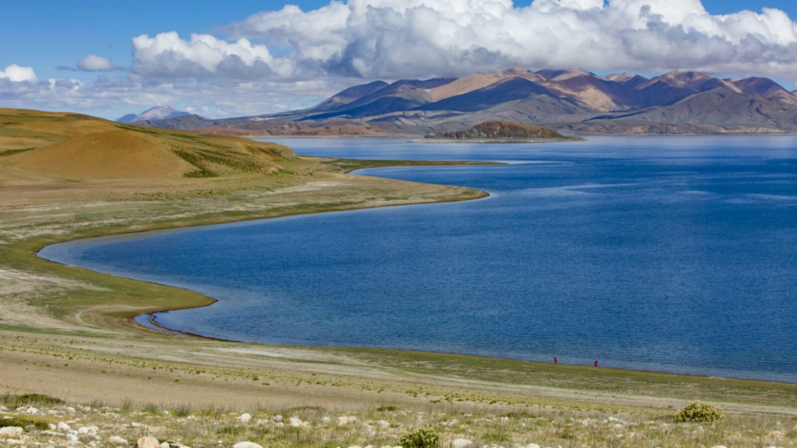
At 4,588 meters on the western Tibetan plateau, Mapang Yongcuo (also known as Lake Manasarovar) holds a position unlike any other body of water in Asia. The lake ranks among the most sacred sites for Hinduism, Buddhism, Jainism, and the indigenous Bön faith — a rare convergence of four major traditions around a single body of water. Pilgrims travel thousands of kilometers to perform the lake kora, a multi-day circumambulation, or to catch the view of Mount Kailash rising on the northern horizon. For foreign visitors, reaching this remote corner of Ngari Prefecture requires careful planning: specialized permits, high-altitude acclimatization, and either a flight or a multi-day overland drive. This guide covers the practical scaffolding — transport options, permit requirements, the kora route, and how to pair the lake with Mount Kailash.
Quick Facts
Why Mapang Yongcuo Is Tibet's Holiest Lake
Lake Manasarovar
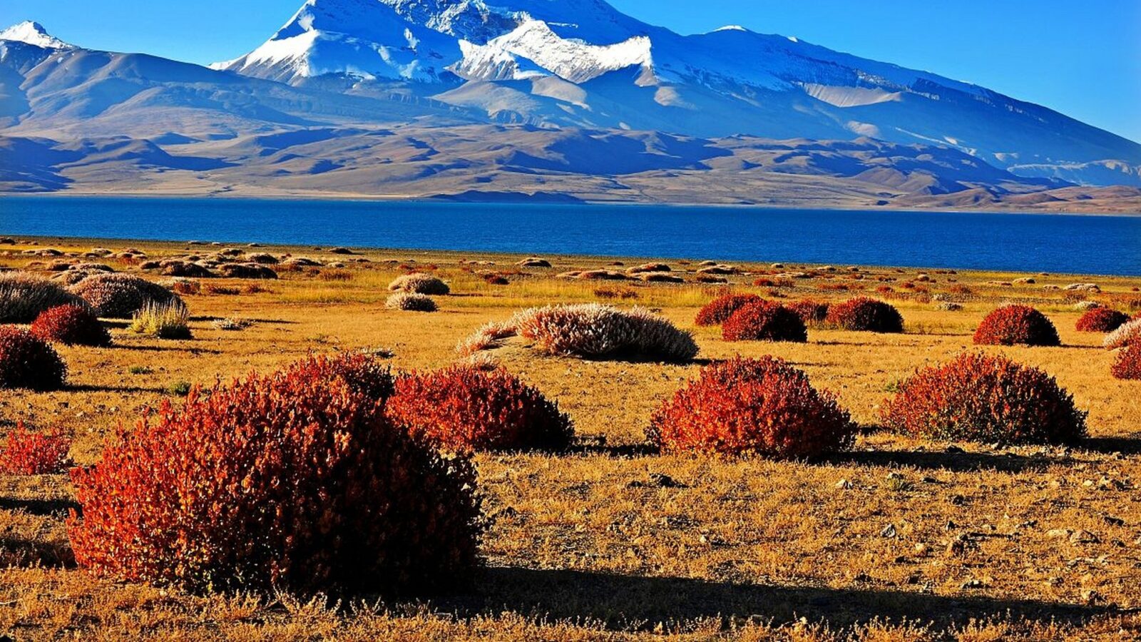
Mapang Yongcuo holds a singular place in Asian religious geography. The lake appears in the founding texts of four distinct traditions — a convergence rarely matched anywhere on Earth. For Hindus, it was formed when the lotus-eyed deity Brahma summoned water from his mind, giving the lake its name Manasarovar, derived from the Sanskrit "mana" (mind) and "sarovar" (lake). Buddhist texts place the lake at the moment Queen Maya bathed there before conceiving Prince Siddhartha, who would become the Buddha. In the Jain tradition, the lake is linked to the first Tirthankara, Rishabhadeva, who is said to have donated his hair at its shore. The indigenous Bön faith, which predates Buddhism in Tibet, holds the lake as Mamo Tso — the "Lake of Compassion" — a site of primordial spiritual power.
Pilgrims across all four traditions believe that bathing in the lake's cold, high-altitude waters washes away accumulated karma from past lifetimes. The surrounding landscape reinforces the sense of scale: the Himalayan chain curves along the southern horizon while the Kailash massif rises to the north, marking the lake as a pivot point between Earth's highest mountain systems.
Four Faiths, One Lake
Hindu tradition describes Lake Manasarovar as mind-born — created by Brahma without physical effort, making it a pure emanation of consciousness. Buddhist texts link the lake to Lumbini's narrative: Queen Maya bathed in its waters before returning home and conceiving Siddhartha Gautama. Jain sources record that Rishabhadeva, the first of 24 Tirthankaras, shed his hair at the lake's edge in an act of renunciation. Bön practitioners, whose animist tradition predates Tibetan Buddhism, revere the same waters as Mamo Tso — the original Lake of Compassion, a site where the boundary between physical and spiritual worlds remains thin. Each tradition assigns the lake a distinct mythology, yet all converge on the same geographic coordinate.
🏔️ Regional Spiritual Highlights: Discover what makes the roof of the world an incomparable destination by reading our overview on What Is Tibet Known For.
Geography of the Lake
Mapang Yongcuo covers approximately 320 km² at an elevation of 4,588 meters, placing it among the highest large freshwater lakes on the planet. The maximum depth reaches roughly 77 meters. Snowmelt from the surrounding Himalayan and Trans-Himalayan peaks feeds the lake year-round, and several major South Asian rivers are traditionally said to originate in its vicinity. The southern shore faces the main Himalayan range; to the north, the Kailash massif forms a dramatic backdrop. The ring of mountains creates a closed drainage basin — water enters as snowmelt and exits only through evaporation, concentrating mineral content while keeping the lake fresh.
The Lake Kora: Circumambulating Mapang Yongcuo
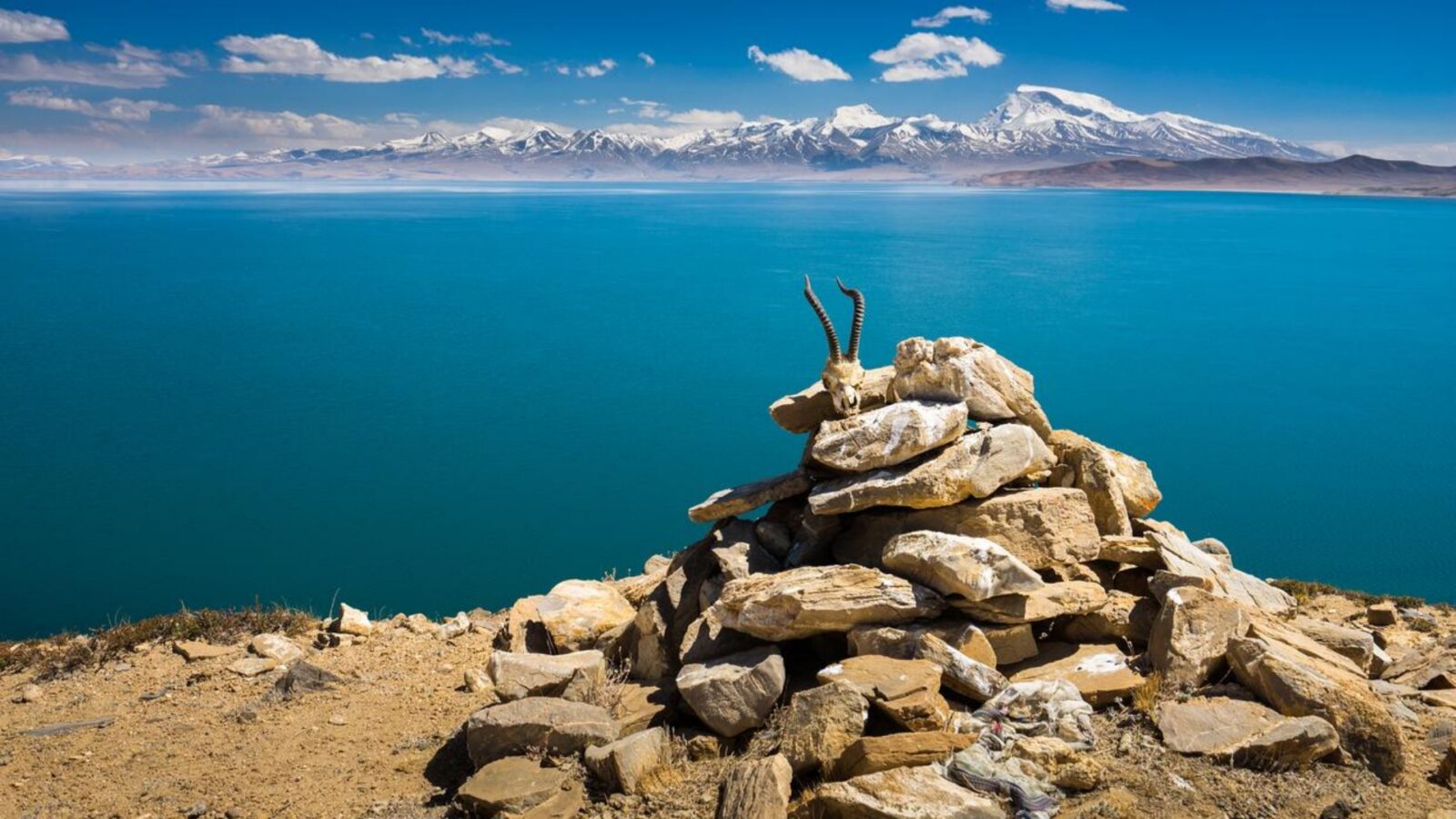
Circumambulating Mapang Yongcuo
The lake kora is the central ritual act for most visitors to Mapang Yongcuo. Unlike the Mount Kailash kora — shorter but far steeper — the Manasarovar circuit follows a longer, gentler path around the lake's perimeter, with a high pass at the southern end and flat marshland on the eastern shore.
Route Overview and Distance
The clockwise circumambulation covers approximately 90–110 kilometers depending on which variant is taken. Most pilgrims and organized groups complete it in 3–4 days at a moderate pace. The standard southern route passes Trugo Gompa on the southeast shore, climbs to Jiu Ge La (approximately 5,150–5,200 m) at the lake's southern tip, descends past Chiu Gompa on the western shore, and returns along the northern bank to Darchen. A shorter option — sometimes called the "short kora" — covers only the southern arc in about 2 days, often with vehicle support on the flatter eastern half. The direction is always clockwise, matching the convention for the Mount Kailash kora.
Stages and Camping
The full kora divides into four stages, each with a designated tent camp. Basic facilities are available at each site: sleeping tents, foam mats, and simple Tibetan meals prepared by the support team. Toilet facilities are primitive throughout. The typical division is as follows:
- Day 1: Darchen / east shore to Seralung or Trugo Gompa (~25 km, flat terrain along the marshy eastern plain)
- Day 2: across the southern plains to the base of Jiu Ge La (~20–25 km, gradually rising)
- Day 3: cross Jiu Ge La pass (~5,150–5,200 m), descend to the western shore near Chiu Gompa (~20 km, steep on both sides of the pass)
- Day 4: return along the northern and eastern shore to Darchen (~25–30 km, flat to rolling)
Practical Tips for the Kora
Layering is essential — temperatures swing from warm sunshine to near-freezing wind on the pass. A down jacket and windproof shell are non-negotiable. Waterproof boots broken in before the trip protect against the marshy eastern sections. UV radiation at 4,800+ meters is intense; SPF 50+ sunscreen, wraparound sunglasses, and lip balm with SPF are required, not optional. Hire a Tibetan guide and yak or porter through the travel agency — rates typically run $50–80 (¥350–560) per day combined. Confirm that your travel insurance covers high-altitude evacuation by helicopter. Finally, do not shortcut the kora or drive clockwise on sections where the path exists; the ritual integrity of the walk matters to fellow pilgrims.
- Clothing: down jacket + windproof shell; layers for sun and cold
- Footwear: waterproof boots broken in beforehand
- Sun protection: SPF 50+, sunglasses, lip balm — UV extreme at 4,800+ m
- Support: hire guide + yak/porter through the agency ($50–80 / ¥350–560 per day)
- Insurance: verify high-altitude evacuation coverage before departure
- Ritual: walk clockwise; do not shortcut on vehicle roads
🛣️ Alternative Gateway Routes: Explore northern overland access points across the plateau with our travel guide to Qinghai Province In China.
Sights Near the Lake and Pairing with Mount Kailash
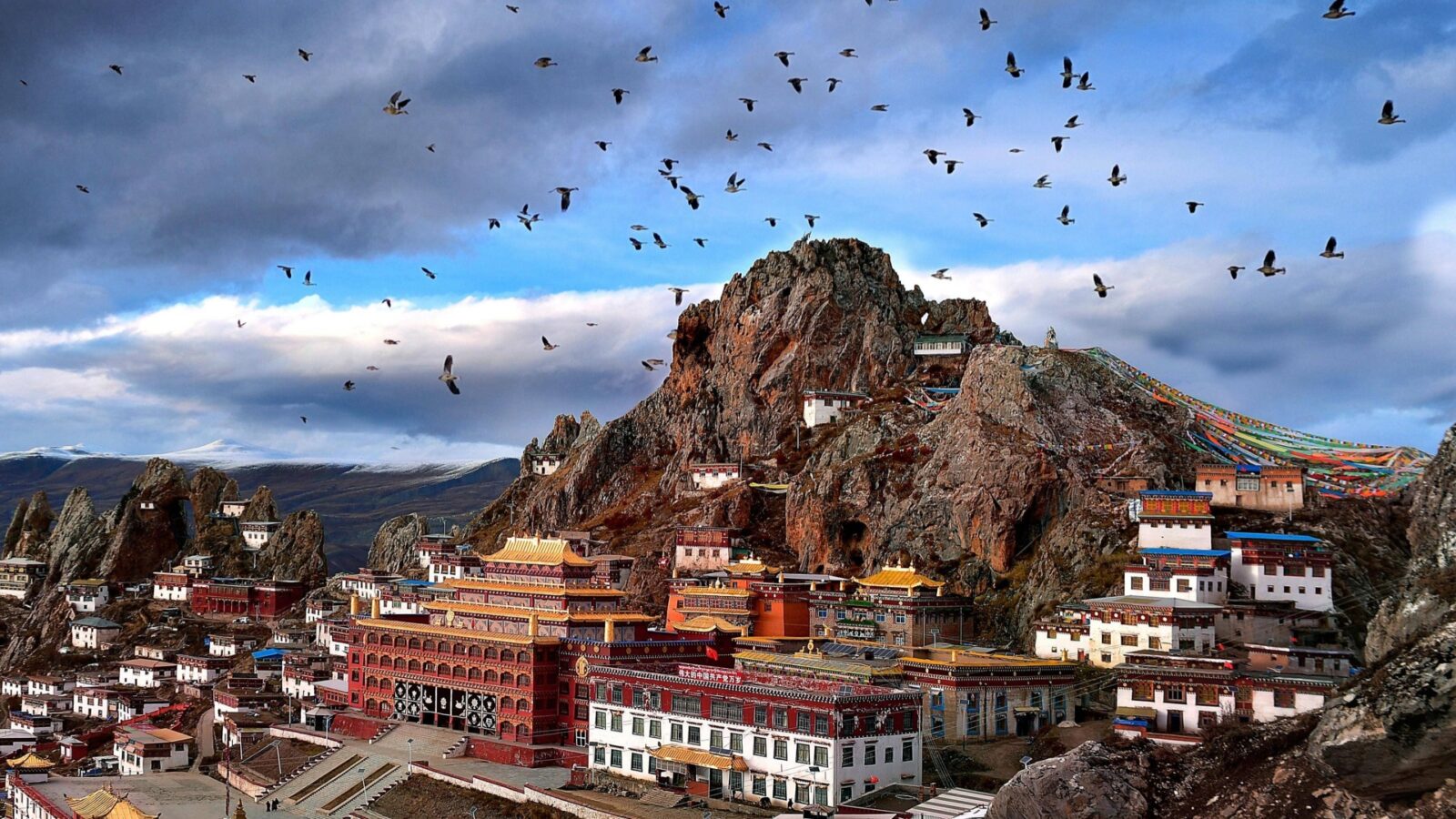
Chiu Monastery
Mapang Yongcuo's most visited sites cluster on the southern and western shores, with the greatest density of religious structures along the kora route itself. A short drive east of the lake opens access to thermal springs that many pilgrims treat as a final purification stop before returning to Lhasa.
Chiu Gompa and the Western Shore
Chiu Monastery (also written as Chiu Gompa or Qiuwu Si) crowns a hillside above the western shore. The site dates to the 11th century and reflects the syncretic Bön-Buddhist tradition that once dominated western Tibet — its main statue depicts Tonpa Shenrab, the legendary founder of Bön. Visitors can climb the hill behind the gompa for what is widely considered the most photographed view of the lake, with Mount Kailash visible on the northern skyline. The monastery marks the natural endpoint of the kora's western arc, and most trekking groups stop here before breaking camp.
Tirtapuri Hot Springs
Approximately 40 kilometers east of the lake on the road back toward Ali, Tirtapuri is a temple and hot-springs complex popular as a post-kora purification stop. Multiple small thermal pools occupy the site, with water temperatures that remain comfortable even in autumn. A modest entry fee covers changing facilities. The springs are modest in scale compared to purpose-built spa destinations, but their religious setting — surrounded by prayer flags and a small temple — gives the experience a different character. Most pilgrims include Tirtapuri as a half-day detour on the return leg toward Ali or Lhasa.
Combining the Lake with Mount Kailash
The standard itinerary for travelers visiting western Ngari pairs Mapang Yongcuo with Mount Kailash. Both sites share the same base town, Darchen, and the road between them is short. Most visitors drive around the full lake perimeter in a half-day, or walk the 2-day southern kora arc, then undertake the 3-day Mount Kailash circumambulation. The Kailash kora is significantly harder: the Dolma La pass sits at approximately 5,636 meters, and the 52-kilometer route gains and loses elevation steeply on both sides. Some travelers choose Manasarovar alone as a quieter alternative — less physically demanding, equally sacred, with views of Kailash from across the water. Combined tour packages covering both sites over 5–7 days after arriving in Ali typically cost $1,800–2,800 (¥12,500–19,500) per person, including permits, transport, driver-guide, accommodation, and the Mount Kailash entry fee.
📜 Permit & Entry Requirements: Learn how mandatory guided tours and entry regulations work by reviewing Can You Visit Tibet.
How to Get to Mapang Yongcuo
Reaching Mapang Yongcuo requires either a domestic flight into western Tibet or a multi-day overland drive from Lhasa. No public transit serves the lake; private 4WD transport is mandatory. The journey from Lhasa to the lake takes a minimum of two days by road, or roughly two hours by air plus a full day of driving from Ali.
Flying to Ali (Ngari) Gunsa Airport
Ali Kunsha Airport (IATA: NGQ) sits at approximately 4,274 meters, about 50 kilometers southwest of Ali (Shiquanhe) town. Daily flights connect to Lhasa, taking roughly two hours, with some services continuing to Chengdu. The schedule is limited, particularly outside peak season, so booking well in advance is essential. One-way fares typically run $230–310 (¥1,600–2,200). All foreign visitors must arrive on a guided tour organized by a registered Tibet travel agency — independent ticketing and self-arranged travel are not permitted in the Ngari region.
💵 Travel Expenses & Cash Prep: Plan your daily remote spending and local payment logistics with our practical guide to Tibet Currency.
Overland from Lhasa
The classic overland route follows the G219 highway west from Lhasa for approximately 1,800 kilometers. The drive takes two days with an overnight stop, typically at Lhatse or Saga. Along the way, passing travelers encounter Yamdrok Lake, a detour toward Everest north base camp, and the Saga crossing of the Yarlung Tsangpo. Tour packages covering the full route from Lhasa to Ali and the lake typically run 10–14 days at $1,500–2,500 (¥10,500–17,500) per person, based on a group of 4–6 sharing a 4WD.
Ali to Burang and the Lake
From Ali (Shiquanhe) town, the G219 continues southwest for roughly 450 kilometers to Burang (Purang) county town, followed by another 25 kilometers to the lake's eastern shore near Darchen. Drive time is 7–8 hours on a paved highway with a single police checkpoint before Burang. The standard vehicle is a Toyota Land Cruiser or Prado 4WD, rented at roughly $150 (¥1,050) per vehicle per day, usually bundled into the tour package. On the final approach, the lake appears suddenly — a wide expanse of blue ringed by mountains, with Mount Kailash visible to the north on clear days.
Permits, Best Season, and Altitude Preparation
Foreign visitors cannot travel independently in Tibet, and the Ali region requires additional documentation beyond the standard Tibet Travel Permit. Planning ahead is non-negotiable: all permits must be arranged through a registered Tibet travel agency before arrival in Lhasa.
Permits You Need
Three separate permits cover a visit to Mapang Yongcuo. The Tibet Travel Permit (TTP) is the baseline document for any foreign visitor entering Tibet and must be collected in Lhasa. The Alien's Travel Permit (PSB) adds access to the Ali prefecture specifically. A Military Permit is required for the Burang border area, including portions of the lake kora route. All three are issued exclusively through a registered Tibet travel agency — individual application is not an option. Submit a full passport scan, China visa copy, and confirmed tour dates at least 15–20 working days before your intended departure. The military permit typically adds $30–60 (¥200–400) to the tour cost.
When to Go
The May–October window covers the full operational season for the Ali region. May and June offer clear skies, stable roads, and thinner crowds before the main summer pilgrim season peaks. September and October provide crisp air, golden landscapes, and the year's best visibility — though nights grow cold. July and August bring the summer monsoon; brief road closures on mountain passes are possible, and pilgrim numbers surge. November through April closes the G219 passes under snow, making overland access unreliable or impossible. The lake surface freezes in the deepest winter. Tibetan New Year (usually February or March) is best avoided — many operators suspend bookings during the holiday period.
- May–June: stable weather, open roads, moderate pilgrim numbers; our pick for first-time visitors
- July–August: warmest daytime temperatures, but monsoon rain can briefly close passes; highest pilgrim traffic
- September–October: clearest skies and best visibility; crisp nights, golden terrain; ideal for photography
- November–April: G219 passes snowbound; overland access unreliable; lake frozen; most operators close bookings
Acclimatizing to 4,500 m+
Altitude affects everyone differently. At 4,588 meters, the lake sits well above the threshold where acute altitude sickness becomes a real risk. A gradual ascent is the single most effective preventive measure. Spend at least two nights in Lhasa (3,650 m) before beginning the westward drive. If flying into Ali, consider stopping one night in Shiquanhe (4,300 m) rather than pushing directly to Darchen (4,675 m) and the lake. Drink three or more liters of water daily at altitude. Avoid alcohol for the first 48 hours. Consider consulting a travel doctor about Diamox (acetazolamide) before departure. Symptoms requiring immediate descent include severe headache unresponsive to medication, persistent vomiting, or breathlessness at rest.
- Minimum Lhasa停留: 2 nights at 3,650 m before driving west
- Ali stopover: 1 night at Shiquanhe (4,300 m) if flying in
- Hydration: 3+ liters of water daily at altitude
- Alcohol: avoid for the first 48 hours
- Medication: Diamox after consulting a travel doctor
- Descent trigger: severe headache, vomiting, or breathlessness at rest — descend immediately
Frequently Asked Questions
Q: How high is Mapang Yongcuo?
The lake surface sits at 4,588 meters (15,049 ft), placing it among the highest large freshwater lakes on Earth. The highest pass on the kora route reaches approximately 5,150–5,200 meters.
Q: Do I need a permit to visit?
Yes. Foreign visitors require three permits for the Ali region: the Tibet Travel Permit, the Ali Alien's Travel Permit, and a military permit for the Burang border zone. All must be arranged through a registered Tibet travel agency 15–20 working days in advance; independent travel is not permitted.
Q: Can foreign travelers do the lake kora independently?
No. Independent travel is restricted throughout Tibet, including at Mapang Yongcuo. The kora must be completed as part of an organized tour with a Tibetan guide, pre-booked tent camps, and yaks or porters arranged through the agency.
Q: How long does it take to trek around the lake?
The full clockwise kora covers 90–110 kilometers in 3–4 days at a steady pace. A shorter southern arc version takes approximately 2 days. Both require the same permit and agency arrangement.
Q: Is Manasarovar freshwater?
Yes. Mapang Yongcuo is a high-altitude freshwater lake fed by snowmelt from the surrounding Himalayan and Trans-Himalayan peaks. It sits in a closed drainage basin where water exits primarily through evaporation.
Q: When is the best month to visit?
May, June, September, and October offer the most stable weather and open roads. July and August bring monsoon rain that can briefly close mountain passes. November through April is generally inaccessible due to snow on the G219.
Q: Can I combine Manasarovar with Mount Kailash?
Yes — this is the standard itinerary for western Ngari. Most travelers base in Darchen and pair a half-day drive or short kora of Manasarovar with the 3-day Mount Kailash circumambulation, totaling 5–7 days after arriving in Ali.
Q: Where do I sleep on the lake kora?
There are no lodges on the kora itself. Four designated tent camps along the route provide basic sleeping tents, foam mats, and simple Tibetan meals. All are pre-arranged by the tour agency.
Q: Is the road to Burang safe for foreign travelers?
The G219 is paved and well-maintained through the summer months, with one main police checkpoint before Burang. Flying to Ali and driving the final 450 kilometers is the faster and more comfortable option for most visitors. Roads are safe but long — allow two days overland from Lhasa if coming by road.